
Navigation for boaters · Beta
Routes for your boat – carefully planned
Free boat navigation for Europe’s waterways: routes with locks, bridge clearances and water depths, daily stages with overnight harbours, and sea charts that also work without a signal.
Beta Test version: navigation is still being trialled and improved. Please always check routes yourself – official notices and signage take precedence.
 Open the BootsNavi.de app ›
Free in your browser – on phone and computer, installable as an app.
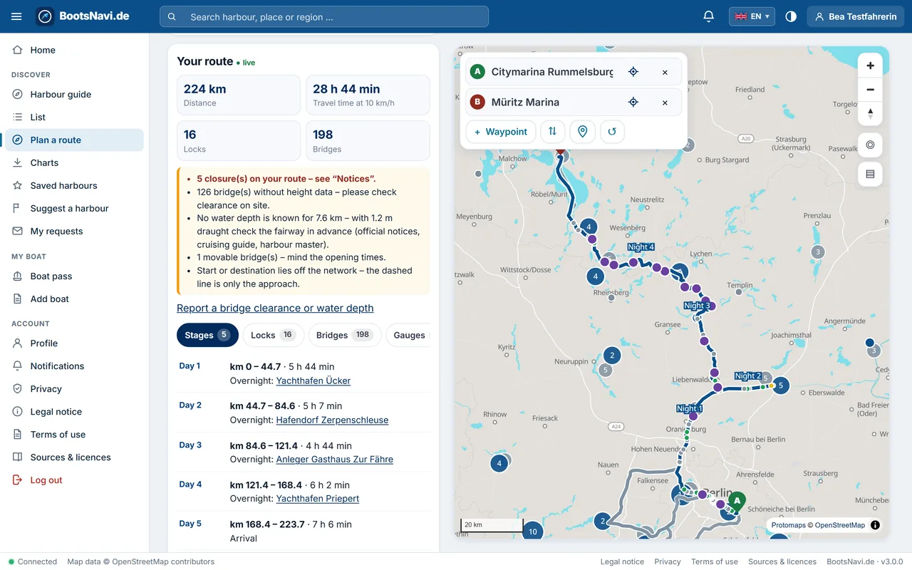
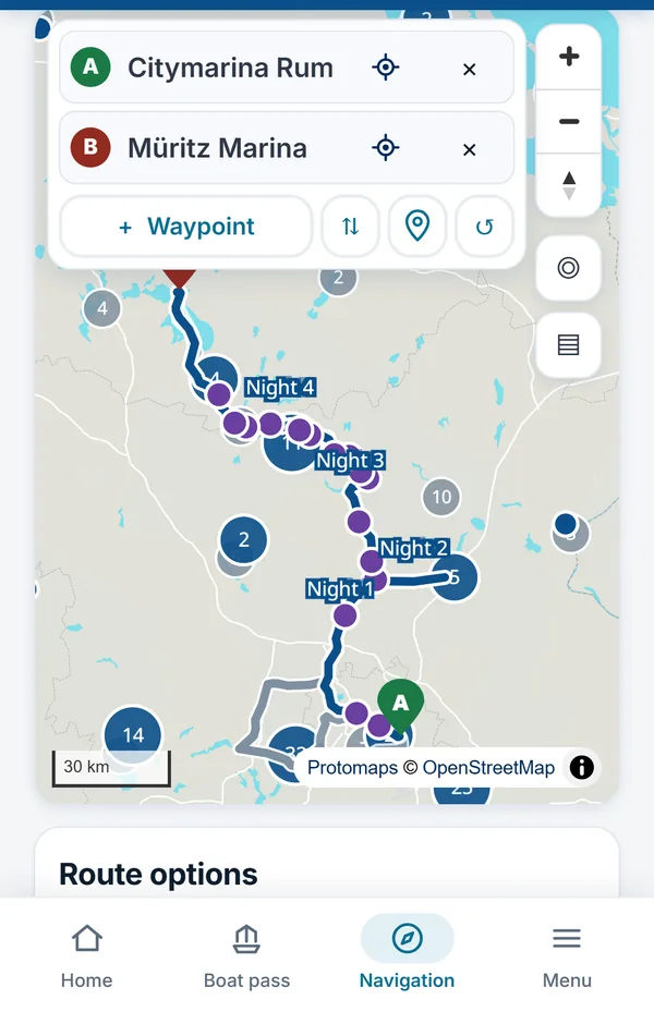
Example: Berlin → Lake Müritz · 224 km · 16 locks · 5 daily stages. Map data © OpenStreetMap contributors, map design Protomaps.
Everything for your trip
- Locks & bridgesRoutes along rivers, canals and lakes – with locks, bridge clearances and travel time.
- Matched to your boatDraught, air draught, length and beam: the route avoids what doesn’t fit and warns where data is missing.
- Daily stagesOvernight harbours along the way – request your berth right from the app.
- Sea charts offlineDownload charts and sea marks for your area in advance – on the water they work without a signal.
- Water levels & noticesWater levels and notices to skippers for German waterways, right on your route.
- 12,288 harboursHarbour guide with visitor berths, facilities and contact details – in 43 countries.
Sea charts for 11 cruising areas
Download charts and sea marks for these areas to your device in advance – on the water they work without a signal. BootsNavi.de plans routes on waterways all across Europe.
- Berlin and BrandenburgBerlin, Potsdam, Brandenburg an der Havel, Spree
- Mecklenburg Lake DistrictWaren (Müritz), Plau am See, Neustrelitz, Fürstenberg
- Western Baltic (Kiel – Lübeck – Wismar)Kiel, Lübeck, Wismar, Fehmarn
- Eastern Baltic (Rostock – Rügen – Usedom)Rostock, Stralsund, Rügen, Usedom
- German North Sea coast and ElbeCuxhaven, Wilhelmshaven, Hamburg, Helgoland
- Wadden Sea (NL/DE)Harlingen, Terschelling, Borkum, Norderney
- IJsselmeer and FrieslandEnkhuizen, Lemmer, Stavoren, Sneek
- Holland and ZeelandAmsterdam, Rotterdam, Vlissingen, Haringvliet
- FlandersOostende, Nieuwpoort, Antwerpen, Gent
- Moselle and SaarTrier, Koblenz, Cochem, Saarbrücken
- Lake ConstanceKonstanz, Friedrichshafen, Lindau, Bregenz
BootsNavi.de app
Find harbours, plan routes, save sea charts offline – plus the digital boat pass. Free of charge.
Open app ›
marina.direct harbour guide
More than 12,000 harbours in 43 countries – with map, visitor berths and facilities. Free of charge.
Find harbours ›
ITN Marina Management
The software for harbours and marinas: berths, bookings, invoices and the app for your guests.
Learn more ›Frequently asked questions
Is BootsNavi.de free?
Yes. BootsNavi.de is free of charge and has no advertising. You can use the map, harbour guide and sea charts without signing in; for route planning and the digital boat pass you create a free account.
Which boats is the route planner suitable for?
Motorboats, sailing boats and houseboats. You enter your boat’s draught, air draught, length and beam; the route avoids bridges that are too low, stretches that are too shallow and locks that are too small, and clearly warns where data is missing.
Which areas does BootsNavi.de cover?
BootsNavi.de plans routes along rivers, canals and lakes across Europe; a coastal route connects harbours on the North Sea, Baltic, Wadden Sea and Mediterranean as a rough plan. Sea charts for offline use are available for 11 cruising areas, from Berlin and the Mecklenburg Lake District to the Baltic, North Sea and Wadden Sea, the Netherlands, Flanders, the Moselle and Lake Constance.
Does BootsNavi.de work without internet?
Partly. You download charts and sea marks for an area in advance, and saved routes and trips open on the water without a signal. New routes are calculated on our server, so your device needs a connection for that.
Does BootsNavi.de show locks, bridge clearances and water levels?
Yes. The route lists locks and bridges with their clearance, suggests daily stages with overnight harbours and shows water levels and notices to skippers along the way for German waterways.
Does BootsNavi.de replace official charts?
No. BootsNavi.de is a planning aid. On the water, the official charts, notices to skippers (for example ELWIS) and your own observation on board apply.
Where does the data come from?
Waterways, harbours, bridges, locks and sea marks come mainly from OpenStreetMap and OpenSeaMap, water levels and notices for Germany from PEGELONLINE and ELWIS, and harbour details from the marina.direct harbour guide.
How do I install the app?
BootsNavi.de runs in the browser on phone, tablet and computer. Use “Add to Home Screen” (iPhone) or “Install app” (Android, Chrome, Edge) to keep it like an app – no app store needed.
Who is behind BootsNavi.de?
IT Service Nietzsch from Willebadessen, Germany, maker of the ITN Marina Management System for harbours and marinas. The marina.direct harbour guide is part of the same family.